Today we are going to get into the nitty gritty by having a look at the San Lorenzo line; known formerly as the Northern Subdivision and completed during the late 1950s or early 1960s, it runs from Quito and heads more or less north to San Lorenzo, a planned site of an alternative port that I understand has never been fully developed as such. The other port linked by rail of course being Guayaquil, but the limitations of the G&Q working against efficient freight movement inward, the alternative port was rather keenly sought. San Lorenzo never achieved this, and so today the port has been developed at Manta further south and now a new line estimated (early 2000s?) at some $60 million may well be built in future.
View Larger Map
In the map you can see the G&Q coming in from the south to Quito and the Q&S heading north out of the capital. We have Panoramio to show us some features of the line and I will highlight some of Senôr H Casanova’s pictures (maybe he is the local train spotter who has walked or cycled over much of the route to San Lorenzo). Also there is not full mapping of this line because at the point at the northern end of Google Earth’s current coverage, there is not anything in Google Maps to show where the line went after that.
Looking at the map to begin with shows us that this is very much a contour railway that was constructed to the cheapest possible cost. It covers many ravines and considering that it was started possibly in the same era as our NIMT was completed, that a completely different scenario was used to cross that landscape is rather striking. In the part that I could examine, something up to two dozen crossings were affected by more or less similar means: a long steep approach in both directions to a tight horseshoe curve at the narrowest point of the ravine where it could be crossed at a relatively low level on an earth embankment with presumably a culvert at the bottom to carry the water, or in some cases a bridge. In New Zealand this is more commonly a feature of roads than railways, because the railway needs to be kept straight and as level as possible to enable it to carry high freight volumes. I don’t really have off the top of my head an adequate comparison for any branch line in NZ but I can’t think of any real equivalent that comes to mind. all the ones that I can think of are roads like the highways near some of our highest railway viaducts that do exactly that. The problem with this approach is the tight curve that you need at the relatively narrow crossing, however in Ecuador such curvature is comparatively routine. The result of these and other decisions is a line that basically zigzags its way across a comparatively flat landscape with only a few hills to begin with. This means of construction has proved to be a fatal flaw as the river valleys are best avoided due to the rainflow, it’s understandable that where most of the damage has been occurring is in those areas and the way to producing a line that could stay open is to stay out of those river valleys and bridge across at the top.
The next question which has not been fully resolved is when the line was abandoned, or at least part of it was; to the north there are still a couple of sections that have operated, at least recently, including Ibarra-Primer Paso (not on this map). What you can see in Casanova’s photos suggests closure or abandonment for a significant period. It’s known that the most severe weather bombs happened in the early 80s and late 90s yet much of the damage of the earlier period was repaired. I believe that it was 1997/98 period of heavy rainfall in particular that has largely been left unrepaired until now and the cessation of through services has allowed the line to quickly show neglect and abandonment.
Here I am going to list some of Casanova’s photos that you can go look at with a commentary (text only, Panoramio does not have a linking API as yet). Some of the photos in this list are also from other authors.
| http://www.panoramio.com/photo/39969154 | A bridge over a highway with missing rails |
| http://www.panoramio.com/photo/11700988 | A bad washout, rails hanging midair |
| http://www.panoramio.com/photo/31055035 | The right of way being used as the entrance to someone’s premises |
| http://www.panoramio.com/photo/31079033 | A bridge at the side of a ravine |
| http://www.panoramio.com/photo/31079054 | A ravine low bridge crossing |
| http://www.panoramio.com/photo/31079135 | Tunnel |
| http://www.panoramio.com/photo/31080018 | Looking down to the bottom of the ravine we just crossed and have climbed out of |
| http://www.panoramio.com/photo/31080198 | Where’s the track? |
| http://www.panoramio.com/photo/31080119 | Crossing a ravine using the shortest possible bridge |
| http://www.panoramio.com/photo/34231953 | Another bit that looks more like a rubber tyred road, fairly steep too. |
| http://www.panoramio.com/photo/30981141 | Ditto |
| http://www.panoramio.com/photo/31020076 | Looking across a ravine to a tunnel on the far side. |
| http://www.panoramio.com/photo/31000915 | Bridge with tunnel at far end |
| http://www.panoramio.com/photo/34261426 | View of a typical ravine crossing with a bridge in this case. |
| http://www.panoramio.com/photo/37519702 | Another such crossing, this one must have been a high embankment that has washed out. |
| http://www.panoramio.com/photo/37520860 | Tunnel to nowhere… almost |
| http://www.panoramio.com/photo/37520941 | Some trackbed that gives an idea of the line’s problems |
| http://www.panoramio.com/photo/7201543 | An actual train near Otavalo. These guys are a bit more formal about riding on the roof. |
| http://www.panoramio.com/photo/997396 | Otavalo |
| http://www.panoramio.com/photo/997323 | And now for something related not railway… |
| http://www.panoramio.com/photo/14317771 | A high bridge near Ibarra |
| http://www.panoramio.com/photo/14317798 | A local train near Ibarra |
| http://www.panoramio.com/photo/17577646 | View of that bridge from a train |
| http://www.panoramio.com/photo/36288063 | Stone arch bridge near Ibarra |
| http://www.panoramio.com/photo/37519602 | Washout |
| http://www.panoramio.com/photo/31008451 | Bad washout with rails in midair |
| http://www.panoramio.com/photo/13694966 | This is the very simple autoferro turntable at Salinas (Primer Paso) where they turn the railbus at the end of its run. |
| http://www.panoramio.com/photo/36508296 | Salinas |
| http://www.panoramio.com/photo/13695062 | An improvised panorama of the Salinas railway station |
I am just coming back to this a couple of days later to comment further on the current operation. Some photos from Flickr are linked below (Flickr allows this). Ibarra-Salinas (Primer Paso) is the remaining 43 km that is open at the moment for tourists. I guess we will see whether any more is fixed up by the government. There are several different railbuses operating the route. It is very obviously geared around that minimalist operation and this is a somewhat sad reflection of how railways have been run down in Ecuador – fortunately I will be able to be more positive about G&Q when I get to writing about that. This means there is a workshop in Ibarra that is just full of old stored rolling stock, locomotives etc that is rusting away to oblivion.
I found one complete photo album on Flickr that has a whole trip worth of photos. That day there weren’t many people who wanted to travel so they went along for the ride with a repair gang in a very small railcar: http://www.flickr.com/photos/9874810@N02/sets/72157601593391119/with/1196701862/
The rest of the photos below are taken from various Flickr albums including some from the album mentioned above.
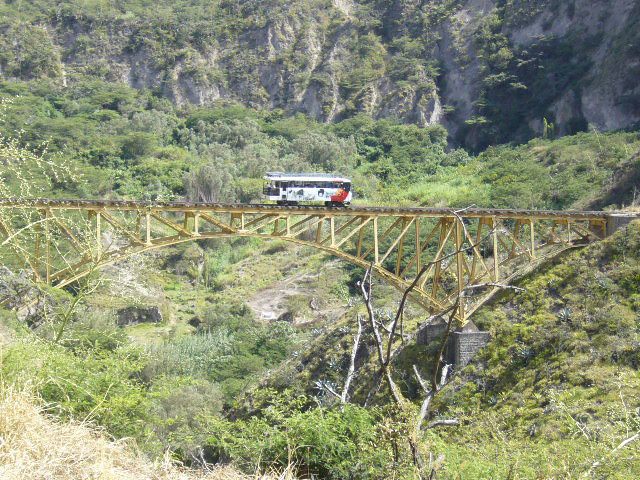
A bridge in the operational Ibarra-Salinas section with a railbus.
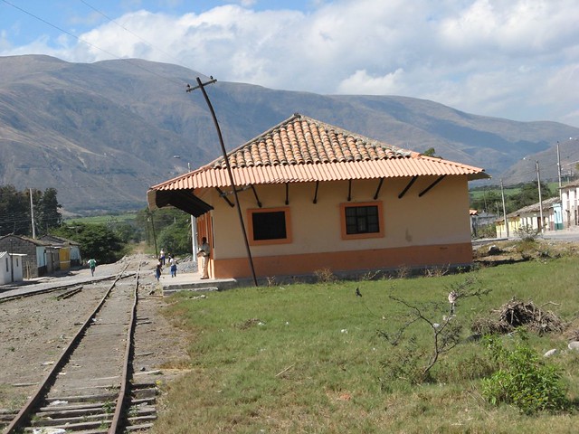
From other photos this appears to be the Salinas station.
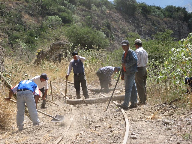
A work gang installing some “sleepers” or “ties” (they had run out of the regular kind so they were using the trunks of small trees).
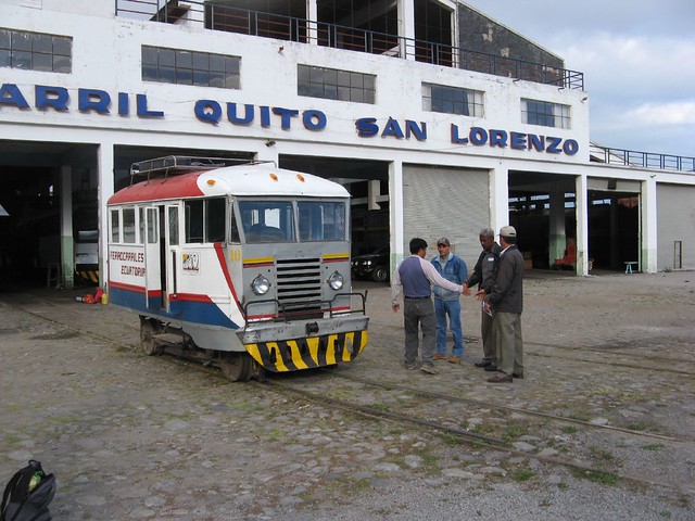
The workshop at Ibarra with the small railcar they were using that day.
I have seen some photos that I can’t link that showed sleepers being unloaded at this workshop – dated about a year ago. The text seemed to suggest they would be put into rehabilitating this section. But what about the rest?

This is from a different album and it shows a different railbus as they are going into a tunnel.
